
Digital Mapping and Public Transport Platforms: Enabling Mobility as a Service (MaaS)
Digital mapping and public transport platforms are two technologies that have revolutionized the way people plan and use transportation. With the increasing penetration of smartphones around the world and the crowdsourcing of data, these platforms are becoming more effective and accurate.
Digital mapping platforms, such as Google Maps and Waze, provide real-time information about traffic, road closures, and alternative routes. This information is incredibly valuable for commuters who need to plan their trips and avoid traffic jams. Digital maps are also important for public transportation systems, as they can help transit agencies optimize routes and schedules based on real-time data.
Public transport platforms, such as Moovit and Citymapper, provide users with real-time information about public transportation schedules and rotes. These platforms make it easier for people to plan their trips using public transportation, and they can help reduce traffic congestion by encouraging more people to use public transportation.
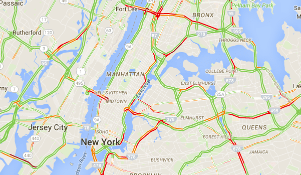
In recent years, there has been a trend toward integrating digital mapping and public transport platforms. Many transportation apps now offer both digital mapping and public transport information in a single platform, making it easier for users to plan their trips and switch between modes of transportation as needed. Integration of digital maps and mobility options can pave the path to building a Mobility as a service (MaaS) app.
Overall, digital mapping and public transport platforms are powerful tools that have transformed the way we think about transportation. They have made it easier for people to plan their trips, reduce traffic congestion, and improve the efficiency of public transportation systems. Google Maps is the most powerful platform which has combined both digital mapping and public transport features.
Check out some other startups which are bringing digital mapping and public transport together:
Moovit is a public transportation platform that provides users with real-time information about public transportation schedules and routes in over 3,000 cities worldwide. Its features include multimodal routing, live updates on transit conditions, and crowdsourced information about transit experiences. Moovit has an urban mobility app with more than 1.5 billion users in 112 countries, covering 7,500 transit agencies and 360 micro-mobility providers. The company is now expanding to build a fully integrated MaaS application. Allowing people to plan, pay, and ride using the same app. A unified mobility manager will help transit agencies to manage services through a single platform.
CityMapper is public transport planning and mapping app, used by around 50 million users around the world. The company allows user to plan their journey and track their movement. The company also launched “CityMapper Pass” to allow users to pay seamlessly through its app for different mobility options. The company is using the Freemium model ad to allow riders to buy premium ad-free service. Further, it uses API and SDK to integrate its solution with other apps. The company is acquired by Via to integrate with its portfolio, which will allow it to integrate with other products including micro transit and urban planning.
Transit app is a public transportation platform that provides users with real-time information about public transportation schedules and routes in over 200 cities worldwide. Its features include multimodal routing, live updates on transit conditions, and crowdsourced information about transit experiences. The app also allows users to purchase mobile tickets and plan trips using different modes of transportation. The app also allows riders to purchase tickets within the app by integrating with all major ticketing platforms including Masabi, Token Transit, Bytemark etc.

Basemap is a transit data analysis startup. The company has launched different products including TRACC (Multi-Modal Travel Time Analysis Tool), Electric vehicle routing, Highway analyst, and Data Cutter. Basemap can analyze data from different sources and integrate it with the map. The company is currently focusing on only on one B2B segment and providing information to its client and does not have a customer interface. The company has its own propriety database as well as used public data, including Point of Interest, Public Transport data and Road Network & census.

Rumbo is a public transport app for emerging markets, powered by WhereIsMyTransport’s data from all formal and informal modes of public transport, as well as crowdsourced data. The app allows people to plan their journey on different transport options (both formal and informal) available in developing countries. The app also shares real-time alerts with riders in case of any disruption using crowdsourced data. Currently, the app is available in 3 cities – Mexico City, Lima, and Bangkok.

Conveyal is a transportation planning and analysis platform that provides tools for urban planners and transportation professionals. Its features include multimodal routing analysis, scenario planning, and real-time data integration. The platform offers a detailed accessibility analysis of transport and land-use scenarios. Conveyal has built a whole library in GitHub which allows any new cities to upload their data and do the analysis. The company uses OpenStreetMap (OSM) to define the street layer of the baseline transport network.

TransSee is a web application that provides real-time bus tracking and next vehicle predictions to a growing list of transit agencies, including most of North America’s largest systems. It has a freemium version and offers an ad-free version to paid users. Currently, it did not integrate other modes of transport and uses public available data to calculate the estimated arrival time.

Maps.me (MapsWithMe) is a navigation and planning app for tourists and travelers, covering more than 70 million points in different cities and having more than 60 million users. In November 2014, it was acquired by Mail.Ru Group and become open source. In November 2020 Mail.ru Group sold Maps.me to the payment processor Daegu Limited

Pantograph is an app that tracks transit systems in real-time, covering over 30,000 vehicles on 4,300 routes from 136 agencies in 14 regions in North America. This is a small startup that launched in March 2019.
About The Author
Jaspal Singh is the Founder of Mobility Innovation Lab (MIL) and Host of the Mobility Innovators Podcast. If you are working on innovative ideas and solving mobility and transportation issues, please feel free to reach out. He loves to talk about startups, mobility, and technology.


